![]()
Excel information reference and Mapping preview.
Within most companies, locations (e.g. shop, or office) are usually referred to by a code rather than a full name, or address. This significantly cuts down on the space requirements necessary to hold the data, and makes entering the code itself quick and easy. It can also be an inconvenience when the code itself, or the name of the location isn't known.
Often a support query will reference details on a report, stating that the details appear incorrect or querying why the details are as they are. The first step in answering this query will usually be to check that query against the report itself. But if the user has only given the location name, and not the location code, this would need to be looked up first.
So we find ourselves continuously (and laboriously)
referring to some sort of reference guide to look up the details. Until now …
The Branch Information and Mapping tool started life to
avoid this issue, linking the store numbers held in the selected cells to a
query against the branch information database, and showing the results on a form
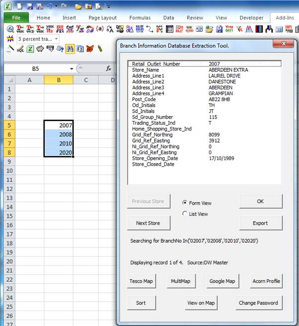
– as shown in the example below ;
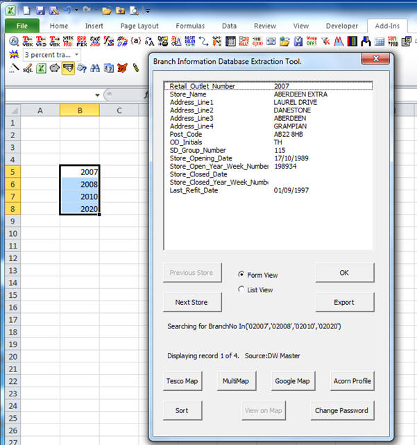
So in the above example, I entered four branch numbers,
and clicked on the icon shaped like a letterbox and letter. This launched the
branch_info add-in, selecting the fields shown from the branch info database for
the selected stores.
Clicking on the Next Store Button will show the details
for store 2008, and once there, clicking previous will go back to store 2007 and
so on.
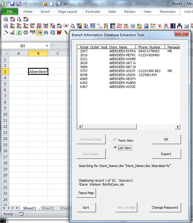
Clicking on the “List View” Radio button will switch from
showing one store at a time, to all on one window …
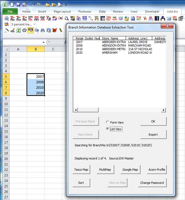
Note, we have scroll bars here to slide the view across
to the other columns on the extracted data, and we can click on the “Form View”
radio button to return to the previous form view.
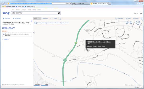
The extracted data includes the postcode on the address
for each individual store. This information can be input against many individual
web sites to show the selected store on a map. So, with Form View being
displayed, against store 2007, clicking “MultiMap” will open bing maps using the
postcode store Aberdeen ;
Clicking the GoogleMaps button would open GoogleMaps with
the postcode, while TescoMap would open the Tesco store locator web site with
that postcode. The Acorn Profile no longer works as the hosting web site has
been replaced with a take-over site that no longer includes this useful
information, but setting up any of these buttons (or adding new ones) to display
new web-links is easy.
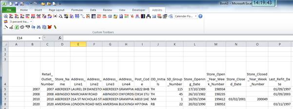
Clicking on the Export button would open a sub-form
allowing the data to be exported onto the current sheet, or a new sheet – this
option can also include more options to display the selected locations together
on one map, but more information on this later.
See below for an example of clicking the export button
exported in seconds ;
As per the details above, I had clicked on the letterbox
icon shown above, and this had returned specific columns set up for that icon.
Other buttons to the right of this allow different data selections to be
extracted, as shown below ;
So here I’ve clicked on the binoculas icon, and different
data is shown, with more location information displayed. You’ll notice that the
“View on Map” button is now available. This is because the extract also included
the “Grid_Ref_Northing” and “Grid_Ref_Easting” positions of the store. This
enables us to show all stores on a map just by clicking on this button ;
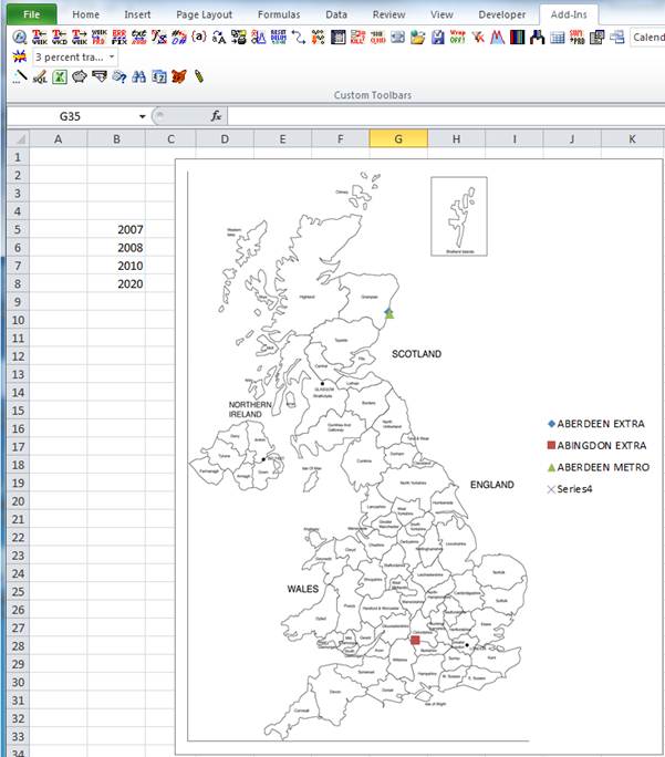
The final point on the map was not included, as the grid
X / Y information wasn’t available for this store. This helps us to gain more
suitable mapping information than a single point on a map, but the export option
allows more GIS related information –
read on for more details...
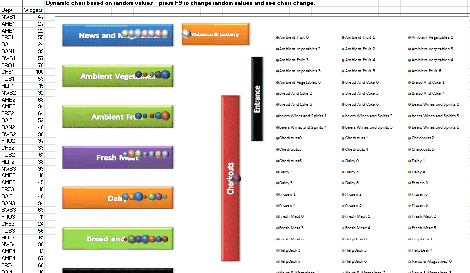
Plus, it's not just about geography. Mapping information can be visually enlightening when looking at data within other locations. Check out the example below where data has been mapped out within a supermarket, in this case showing "widgets" within different areas of the supermarket represented by different point sizes / colours within the exact area of the supermarket that they exist. The data plotted could just as easily be sales / stock / customer throughput / etc... Read More ...
As mentioned above, the lookup of data is not simply limited to the location code. If I knew the name of the location, or part of the name, I could look up the location code and other related information by entering that name ...
There are many other options for searching by other fields, with the SQL Wizrad icon available for creating complex location search queries, and the magic wand available for setting up new icons on the toolbar to return different search criteria. The location lookup tool can be configured to work against any input source, so it is not just locations that can be looked up, but products for example. Read on for more details of these features ...